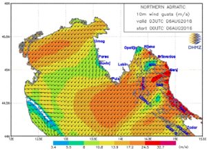
The Bora is wreaking havoc with our sailing plans this month. We’re currently in harbor again on the island of Cres on waiting for another Bora wind to start. Fortunately this event is expected to be short in duration; 18 hours of plus 30 knot winds are forecast. During the last Bora which was less than a week ago, a particularly wild wind gust, recorded 47 knots of wind on our wind instrument. That’s almost 90 km/h!
As a novice sailor you do not want to be out on the sea when the Bora is blowing. It tends to produce gusty and unpredictable conditions with steep waves that are potentially very dangerous and certainly highly uncomfortable. However, the irony is that the Bora blows the strongest closest to land, so to avoid sailing during a Bora, you actually experience some of the strongest winds the Bora has to offer.
The Bora originates in the Croatian Alps. As the air around the mountains cools, it becomes more dense than the air around it and consequently it starts to fall down the mountain. As it falls it comes into contact with progressively warmer, less dense air and its slide down the mountain accelerates. This type of wind is called a fall wind, or more commonly a katabatic wind because katabatic is Greek for “descend”. Because the Bora originates in the mountains, it is heavily influenced by the terrain. Valleys and channels tend to accelerate the Bora and as such there tends to be Bora hotspots across the eastern Adriatic coastline. One in particular is the Velebit Channel, where winds in excess of 250 km/h have been recorded (although hurricane strength Boras tend to be in the winter, thankfully). Another Bora hotspot is the Kvarner Gulf, where we happen to waiting this particular Bora out.
So why doesn’t the Bora blow all the time? Most of the time the katabatic process is weak and offset by other conditions, such as the sea breeze. However, when the synoptic conditions are right, which tends to be a high pressure system over the mountains and lower pressure over the Adriatic Sea, then the Bora will blow until the pressure gradient is reduced. Unfortunately for us, a steady procession of atmospheric ridges and troughs over the Adriatic has meant we have experienced a number of Bora winds almost back to back.
Summer winds in the eastern Adriatic are usually dominated by a north westerly wind called the mistral, which starts late in the morning and dies away in the early afternoon. This wind is supposed to be an idea sailor’s wind; consistent but not too strong. Aside from a couple of great sailing days, we haven’t seen much of the mistral yet, but we live in hope that these ideal sailing conditions will find us soon.
I consider us luckier than most given the current situation with the winds. A few days in harbor represents a chance to get some schooling, boat maintenance and work done. For those who have spent a lot of money to charter a boat for a week, a Bora can annihilate nearly half of their holiday. Obviously this is a huge disappointment and I would think that it the risk of a Bora would be a serious consideration for anyone planning a charter holiday in Croatia. Over the weekend, we saw one impatient charter group run their boat onto some rocks because they decided to leave port before the Bora had run its course. While I understand the desire to go sailing, taking an unfamiliar boat out in challenging conditions is never a good idea, as these sailors found out the hard way.
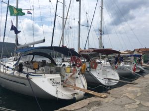
Tonight, we’re packed tightly into the old town harbor in Cres to wait out the Bora. Hopefully it will be short as forecast and we can be back sailing soon.
Hi there. Thank you…Great article.